
Orienteering belongs in the olympics
Studio Videnda created this data-driven artwork in support of a campaign to make orienteering an Olympic sport. This work accompanied a list of reasons why orienteering deserves elevation to Olympic status. The document and an associated brief video were published and forwarded to supporters of the cause to share with Olympic decision-makers.
The following panels describe the history, buildup, and components of Orienteering Belongs in the Olympics.

The work starts with part of Section 31 of the LBJ National Grasslands. Grasslands? Dispel images of vast flat prairie. There are some open rolling areas, but much of this cross timbers region consists of forest, underbrush, steep-banked creeks, and even small cliffs. The center of this ~5 km2 area is at ~33.3643, -97.5933 in Wise County, Texas, north of Decatur. The area looks like this viewed from above (courtesy Google; enhanced by Studio Videnda):

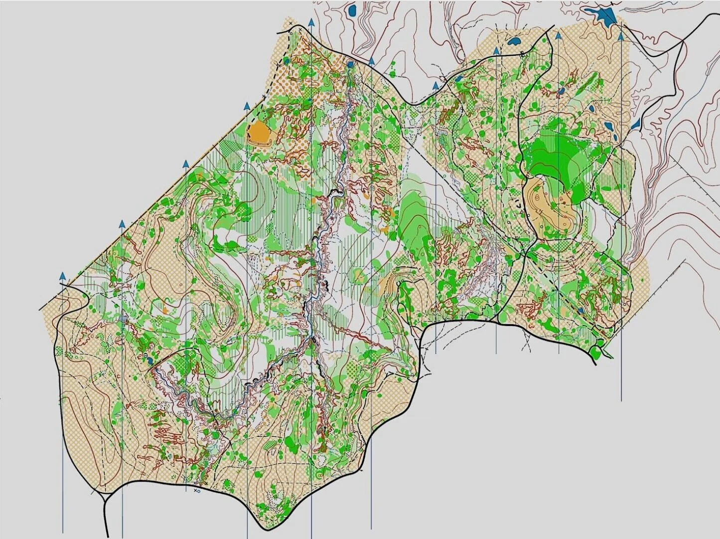
The North Texas Orienteering Association (NTOA) uses this portion of the Grasslands for its annual spring “Dillo Goat” meet. When mapped in detail according to orienteering terrain and feature coding, the area appears as below (courtesy NTOA, including member Tatyana Svistun and others). Competitors depend on and appreciate the painstaking detail. Contour intervals are 2.5 m (8.2 ft). Mean elevation is 280 m (919 ft) with changes of up to 50 m (164 ft).
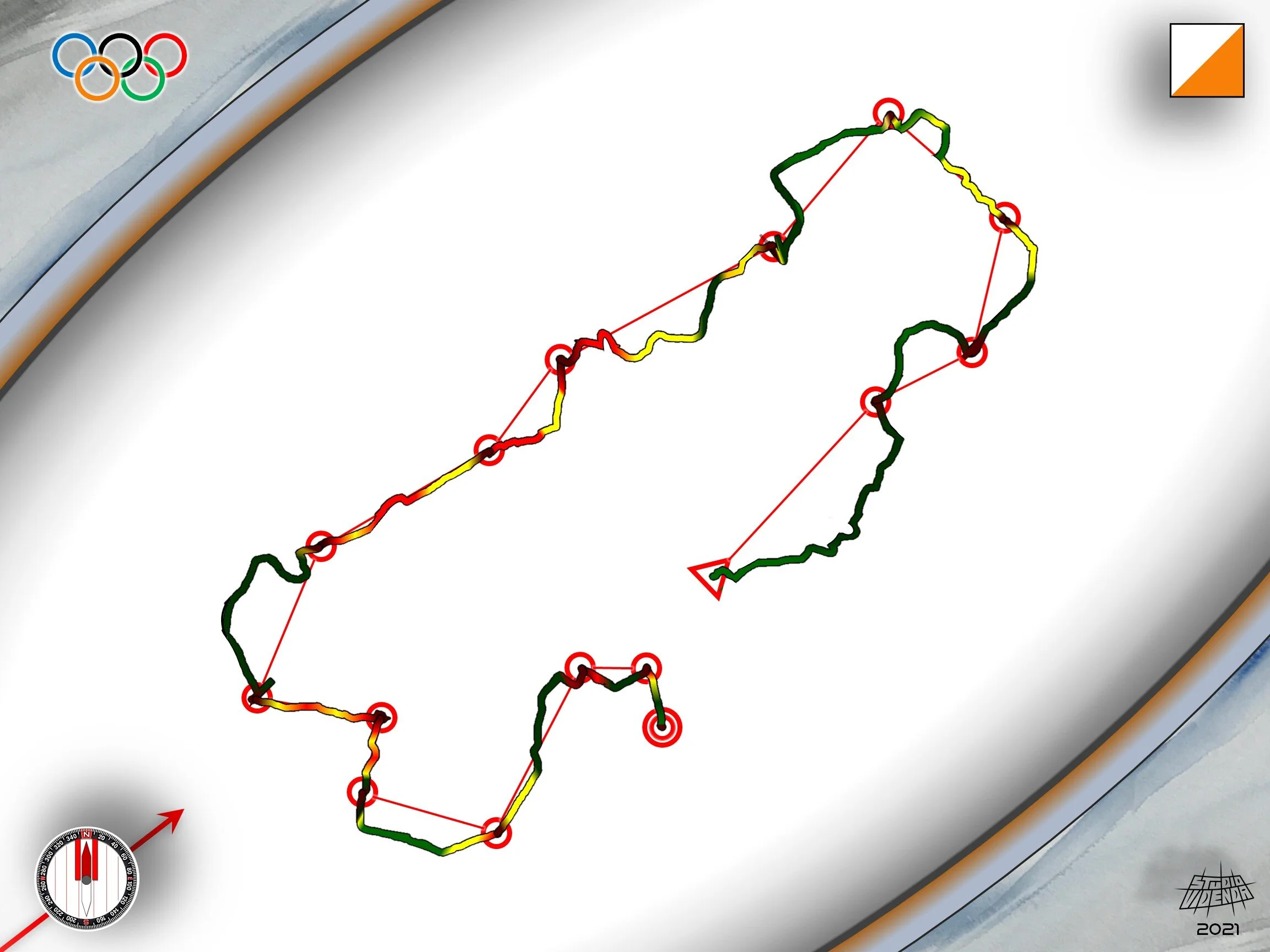
Red on this panel marks a medium difficulty orienteering course set in the mapped area. The triangle marks the start, and concentric red circles designate the finish. Single red circles indicate the 14 control points that must be found, in order, from start to finish. Each control has a clue (described below). Total point-to-point straight-line distance for this course is 4.8 km.

This panel superimposes the path of an actual competitor on the course map. Color-coding indicates to how fast they can go depending on elevation changes, vegetation, obstacles, and other terrain features: green = fast, yellow = moderate, red = slow. Moderate-level courses like this invite running along “handrails” (trails, roads, fencelines, etc.). Handrails become less of an option on more difficult courses: you run across trails instead of on them!

This panel isolates the course and competitor path to illustrate how much an orienteer may deviate from the direct line between two control points. In this case, they ran ~7.5 km to complete the ~5 km course. Why? The fastest groundpath from one point to the next is almost never “as the crow flies”. Again, on a medium-difficulty course, handrails often explain deviations from a straight line: faster to run a winding trail than dive into a dense thicket.

This panel illustrates hypothetical aerial drone stations to allow viewing of competitors as they run the course. This type of competitor monitoring along with videography on the ground, bodycam video, and GPS tracking, make orienteering among the best of spectator sports. Major orienteering competitions and televised adventure races already use such viewer-friendly technology.

This section describes some of the competitor’s thought processes as they run the course illustrated above.
START to 1. Use the easterly road then northeasterly trail as handrails. Follow the trail for about 250 meters until you cross a fence line. The trail Ts into another and turns northwest shortly after a trail junction. Be careful here that you know which trail is which. Split right on the trail at a special feature. Control point 1 will be ~ 70 m after at a second similar special feature.
1 to 2. Head generally northeast across available open space < 100 m to connect to a road heading north. Follow that road around the hillock on the right <100 m and turn right on a major trail going east. This path avoids the shorter but more strenuous path over the trailless hillock. Keep left where the trail splits and curve South about 100 meters through a wooded thicket. As you emerge from the thicket, look for marker 2 about 20 m east on rootstock at the southern edge of the thicket.
2 to 3. Find and follow a small northeasterly trail which starts about 20 meters northeast of control 2. After about two hundred meters it will emerge from woodlands into open space. Go downhill and directly north about 100 meters from that point to the southwest edge of a small pond. Follow a bearing of 315° northwest for about 100 meters to a small marsh. The #3 kite is on the western edge of the marsh.
3 to 4. Follow a bearing of 310° for at least 200 meters until you intersect a road running southwest northeast. Follow the road northeast / north about 50 meters until you can cut across open terrain on the left to the northwest. Intercept and take another road heading southwest approximately 50 meters. Turn off the road to head across open space straight north about 50 meters to a pond. Marker #4 will be on the south edge of that pond.
4 to 5. Re-acquire the road you were just on and head about 250 meters southwest. Take a southeasterly trail off that road. In about 100 meters that trail will split. Take their right or South southeasterly branch. In less than 100 meters that rail will curve to head directly South. At that point, head through heavy brush directly West of the trail 4 30 meters. Marker #5 will be at the base of a small hillock in a small clearing.
5 to 6. Follow a bearing of 240° a little over 100 m to a trail junction, then take the trail bearing 195° 150 m. From there follow a bearing of 265° for 300 m using waypoints. This will be difficult. At 200 m you should descend to and cross a creek. A cliff edge should be on your left after ascending the opposite bank. Follow the heading 100 m after the creek through heavy vegetation. Kite 6 is on the west end of a small hillock.
6 to 7. Go 150 m directly south, then follow bearing 250° 150 m through increasingly dense vegetation. Control 7 is on the west end of a small hillock.
7 to 8. Follow a bearing of 240° using waypoints for a little over 400 m. Marker 8 is on the east edge of a clearing.
8 to 9. Briefly continue on bearing 240° to intercept and turn left on a trail. Carefully negotiate a trail network to stay on the correct one for ~400 m. Just before the trail suddenly descends sharply, control point 9 is at the top of a southeast facing cliff just to the right (southwest).of the trail.
9 to 10. Follow a bearing of 100° for 260 m using waypoints as needed. Marker 10 is in the middle of a gully.
10 to 11. Take bearing 190° for 160 m. Control 11 is where a trail crosses a small hillock.
11 to 12. Continue bearing to a road, go left (east) on the road 200 m until it starts to curve south, then cut off bearing 65° for 110 m. Marker 12 is on the south edge of a thicket.
12 to 13. Bear 150 m then head ~250 m generally NE along a trail. Kite # 13 is at the junction of a gully and wet ditch.
13 to 14. Follow a trail from # 13 generally east for 150 m. Marker 14 is on the north edge of a thicket.
14 to FINISH. The finish funnel starts ~ 100 m bearing 165° from control 14. Sprint, you dog! Leave it all on the course.
REFERENCES
https://en.wikipedia.org/wiki/Orienteering
https://www.rei.com/learn/expert-advice/orienteering-basics.html
